Illinois is one of the 50 states of the United States of North America. The stat is located in the Midwest region of the US and counts 12,869,257 (2011). The capital is Springfield and the standard abbreviation is IL.
Illinois borders Wisconsin to the north, Iowa and Missouri to the west, and Indiana and Kentucky to the east. To the north, the state is located on Lake Michigan.
The western border of Illinois is delineated by the Mississippi River, part of the southeastern border by the Ohio. The Illinois River, a tributary of the Mississippi, runs right through the state.
Rows of hills lie along the Wabash and Mississippi. These are called “river bluffs”. The Illinois Ozarks are located in the south of the state. This is a continuation of the Ozark Plateau.
Lake Michigan (Lake Michigan) is one of the five Great Lakes of North America. The lake has an area of more than 58,000 km2. It is the largest freshwater basin in the United States.
The main port on Lake Michagan is Chicago.
Climate and Vacation
The climate of Illinois is characterized by great extremes of heat and cold. Tornadoes occur regularly in the state.
Starved Rock, with its jagged limestone formations, is a popular tourist attraction. The park is 100 miles southwest of Chicago.
The Cahokia Mounds State Historic Site contains Native American burial mounds. Furthermore, the Apple River Canyon State Park, the Dixon Springs State Park with more than 1,500 waterfalls and the Giant City State Park are beautiful sights.
Cahokia
Cahokia is the site of an ancient Native American city. This city existed from about 650 to 1400.
The city was located on the Mississippi, near present-day Collinsville, and at the time was the largest city north of the Rio Grande. The location is on the UNESCO World Heritage List.
Cities Illinois
In addition to the capital Springfield and the largest city in the state, Chicago, there are a number of other cities in Illinois: Aurora, Rockford, Joliet, Naperville, Peoria, Elgin, Waukegan, Cicero.
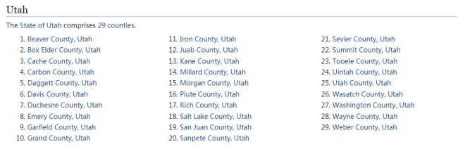
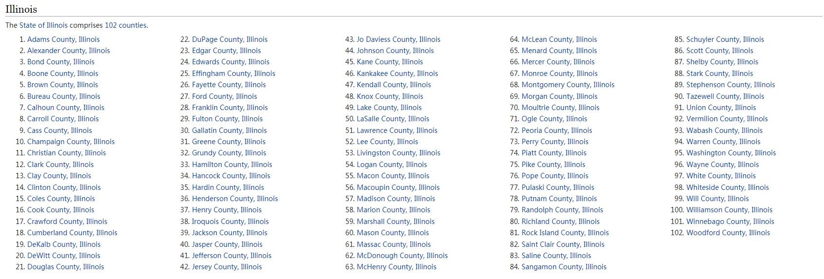
Counties Illinois
Illinois is divided into 102 counties.
Airports
Chicago’s O’Hare International Airport (ORD) is one of the busiest airports in the world. Another airport near Chicago is Chicago Midway International Airport (MDW).
Illinois
Illinois borders the states of Wisconsin, Iowa, Missouri, Indiana, and Kentucky. The state is located in the north on Lake Michigan. The capital is Springfield.
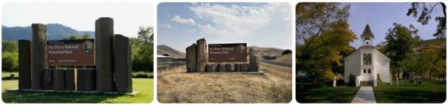
Lewis & Clark National Historic Trail
Between 1804 and 1806 there was an expedition led by Meriwether Lewis and William Clark to explore the Missouri River and its tributaries. The expedition was approved by the then president of the United States, Thomas Jefferson, and a total of 33 men took part in it, of which 25 were volunteers.
The goal was to see if the Columbia, Oregon, and Colorado rivers offered any practical, direct water route across the continent. The expedition thus followed the path to the Pacific, while traveling more than 8,000 miles. Preparations for this journey had been going on since the spring of 1803. The entire expedition finally set off on the expedition on May 14, 1804, from the Camp Wood camp near the Wood River in the state of Illinois. Already in August of the same year, the expedition reached Nebraska and South Dakota. However, problems began in North Dakota, where the temperature reached a freezing -40°C and the group had to set up camp for the winter.
The expedition continued towards the Pacific Ocean and on the way she often met native Indians who helped her in many ways. Clark once helped a young Native American girl give birth to a son, and it would pay off a hundred times in the future. The Shoshone Indians were very grateful and helped the expedition cross the Rockies. In August 1805, they therefore reached Montana, where they learned from the Indians how to make dugout canoes. They were thus able to navigate the Clearwater and Columbia Rivers and on November 24, 1805, they finally found themselves on the shores of the Pacific Ocean.
With the coming of winter, they were forced to build another winter camp. They placed it near an Indian tribe called Clatsop, and a fort of the same name was later built at this place. Everyone got through the winter in order, because it was completely classic and almost all of it rained. As soon as it warmed up a bit and spring began to arrive, the expedition set off on the return journey. On September 23, 1806, a group of adventurers returned home to St. Louis as heroes.
This expedition made a significant mark in the history of America and is considered a deed that changed the face of the country. Thanks to her, it was possible to find out that the longed-for northwest route, along which it would be possible to transport cargo by water from the middle of America to the west coast, unfortunately does not exist. One of its participants died during the expedition, but it could still be considered very successful. All other members completed it and returned home safely.
Another reason why this expedition was undertaken was to obtain the center of the continent for America. The English occupied the territory from the north and the Spanish from the south. Therefore, the center of the continent could only belong to the one who thoroughly explores it and thus obtains it for his land.