North Dakota is one of the 50 states of the United States of North America. The state is located in the northwest of the Midwestern region of the US and has 683,932 inhabitants (2011). The capital is Bismarck and the standard abbreviation for the state is ND.
North Dakota, also called North Dakota in the Netherlands, borders the state of Minnesota in the east, South Dakota in the south and Montana in the west. To the north, the state borders Canada.
On November 2, 1889, North Dakota and South Dakota formally became the 39th and 40th states of the United States.
Part of the state falls within the Great Plains. This is a plateau that stretches between the Missouri and the Rocky Mountains.
The eastern part of the state is covered in grassy plains, which flow west into the Missouri Coteau, and then into the steppe landscape of the Great Plains, which extends far into neighboring Montana.
In the southwest of North Dakota lie the barren Badlands. These are jagged mountain formations. White Butte is the highest point in the state at 1,069 meters above sea level.
Lakes and Rivers
The Red River of the North forms part of the border with Minnesota. Tributaries of the Red River of the North in North Dakota are the Sheyenne and Souris Rivers.
The Missouri with numerous tributaries lie in the south and west of the state.
Lakes and lakes known as prairie lakes are scattered all over the state of Noth Dakota.
Lake Sakakawea is a large man-made lake in the western part of the state.
Climate and Vacation
North Dakota has a continental climate, with a low average amount of annual precipitation. The state is regularly hit by tornadoes.
An important tourist attraction in the state is the Theodore Roosevelt National Park, with beautiful natural beauty also the Elkhorn Ranch, the former ranch of former US President Theodore Roosevelt.
In the southwest of the state are the jagged Badlands, characterized by a strong incision, numerous fissures, erratic erosions and brightly colored rocks.
Knife River Indian Villages National Historic Site recalls the Native Americans who inhabited the area
Frontier Village and Bonanzaville USA keep the memory of the pioneer days alive.
Cities North Dakota
Besides the capital Bismarck and the largest city of the state Fargo are a number of cities in North Dakota: Grand Forks, Minot, West Fargo, Mandan, Dickinson, Jamestown, Williston.
Wahpeton, Devils Lake, Valley City, Grafton, Beulah, Rugby, Horace, Hazen, Lincoln, Casselton, Bottineau, Lisbon, Carrington, New Town, Langdon, Mayville.
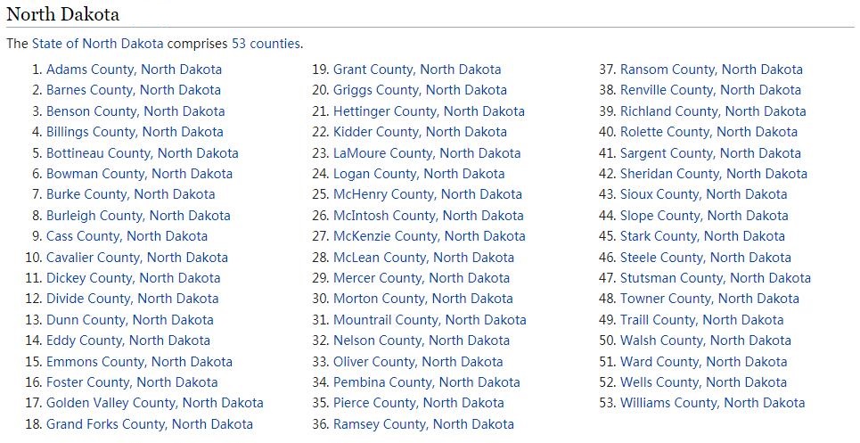
Counties North Dakota
North Dakota is divided into 53 counties.
Lewis & Clark National Historic Trail
Between 1804 and 1806 there was an expedition led by Meriwether Lewis and William Clark to explore the Missouri River and its tributaries. The expedition was approved by the then president of the United States, Thomas Jefferson, and a total of 33 men took part in it, of which 25 were volunteers.
The goal was to see if the Columbia, Oregon, and Colorado rivers offered any practical, direct water route across the continent. The expedition thus followed the path to the Pacific, while traveling more than 8,000 miles. Preparations for this journey had been going on since the spring of 1803. The entire expedition finally set off on the expedition on May 14, 1804, from the Camp Wood camp near the Wood River in the state of Illinois. Already in August of the same year, the expedition reached Nebraska and South Dakota. However, problems began in North Dakota, where the temperature reached a freezing -40°C and the group had to set up camp for the winter.
The expedition continued towards the Pacific Ocean and on the way she often met native Indians who helped her in many ways. Clark once helped a young Native American girl give birth to a son, and that would come back to him a hundred times in the future. The Shoshone Indians were very grateful and helped the expedition cross the Rockies. In August 1805, they therefore reached Montana, where they learned from the Indians how to make dugout canoes. They were thus able to navigate the Clearwater and Columbia Rivers and on November 24, 1805, they finally found themselves on the shores of the Pacific Ocean.
With the coming of winter, they were forced to build another winter camp. They placed it near an Indian tribe called Clatsop, and a fort of the same name was later built at this location. Everyone got through the winter in order, because it was completely classic and almost all of it rained. As soon as it warmed up a bit and spring began to arrive, the expedition set off on its return journey. On September 23, 1806, a group of adventurers returned home to St. Louis as heroes.
This expedition made a significant mark in the history of America and is considered a deed that changed the face of the country. Thanks to her, it was possible to find out that the desired northwest route, along which it would be possible to transport cargo by water from the center of America to the west coast, unfortunately does not exist. One of its participants died during the expedition, but it could still be considered very successful. All other members completed it and returned home safely.
Another reason why this expedition was undertaken was to obtain the center of the continent for America. The English occupied the territory from the north and the Spanish from the south. Therefore, the center of the continent could only belong to the one who thoroughly explores it and thus obtains it for his land.