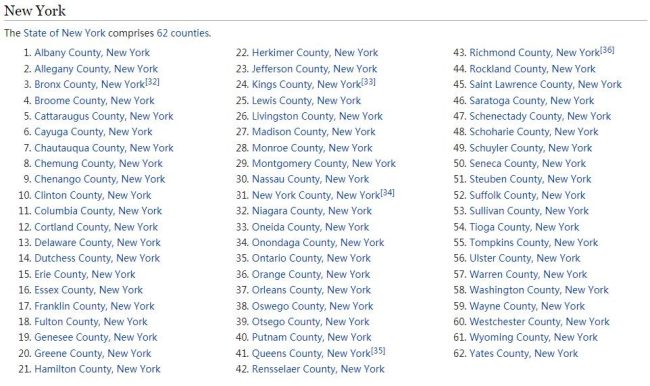
Nestled in the heart of the Appalachian Mountains, Taylor County in West Virginia boasts a captivating geography characterized by its rolling hills, lush forests, and abundant waterways. From the picturesque Tygart Valley River to the rugged terrain of the Allegheny Plateau, Taylor County’s landscape has shaped its history, economy, and culture. This comprehensive overview will explore the geography of Taylor County, including its population dynamics, climate patterns, and the prominent rivers and lakes that define the region.
Location and Boundaries
Taylor County is located in the north-central part of West Virginia, bordered by Barbour County to the east, Harrison County to the west, Marion County to the south, and Preston County to the north. The county covers an area of approximately 176 square miles, making it a relatively small county in the state. Check Fun-Wiki.com to learn more.
Population
As of the latest census data, the population of Taylor County stands at approximately 16,000 residents. The county is primarily rural, with small towns and communities scattered throughout its hills and valleys. Grafton, the county seat, serves as the largest town and is a hub for commerce, education, and healthcare. Over the years, the population has experienced fluctuations influenced by economic factors, migration patterns, and changes in industry.
Climate
Taylor County experiences a humid continental climate, characterized by four distinct seasons. Summers are warm and humid, with average temperatures ranging from the mid-70s to low 80s Fahrenheit. Winters are cold and snowy, with temperatures often dropping below freezing, particularly in the higher elevations. Annual precipitation is ample, with rainfall spread relatively evenly throughout the year, while snowfall is more common during the winter months. The climate is conducive to agriculture, forestry, and outdoor recreation, with the changing seasons adding to the region’s natural beauty.
Topography
The topography of Taylor County is defined by its rugged terrain, rolling hills, and scenic valleys. The county lies within the Allegheny Plateau region of the Appalachian Mountains, characterized by steep ridges and narrow valleys carved by centuries of erosion. Elevations in Taylor County vary, with the highest points reaching over 2,000 feet above sea level in the eastern part of the county. The Tygart Valley River, along with its tributaries, meanders through the county, cutting deep valleys and providing fertile soils for agriculture.
Rivers and Lakes
Taylor County is blessed with an abundance of waterways, including rivers and lakes that play vital roles in the region’s ecology and economy.
Tygart Valley River: The Tygart Valley River is the primary river in Taylor County, flowing from its headwaters in Pocahontas County through the Allegheny Mountains before converging with the West Fork River to form the Monongahela River. The Tygart Valley River and its tributaries provide habitat for various fish species, including trout, bass, and catfish, making it popular among anglers and outdoor enthusiasts.
Lakes: While Taylor County does not have large natural lakes, several reservoirs and impoundments dot the landscape, providing recreational opportunities and serving various purposes such as flood control and water supply. These include:
- Tygart Lake: Located in neighboring Marion County, Tygart Lake is a scenic reservoir created by the Tygart Valley River. The lake offers boating, fishing, camping, and hiking opportunities, attracting visitors from across the region.
- Teter Creek Lake: Situated in the eastern part of Taylor County, Teter Creek Lake is a small impoundment surrounded by forested hills. The lake is stocked with trout and supports a healthy population of warm-water fish species, making it a popular destination for fishing and picnicking.
Ecology and Biodiversity
The diverse geography of Taylor County supports a rich array of ecosystems and biodiversity. The forests of oak, hickory, and maple trees provide habitat for a variety of wildlife, including deer, black bear, wild turkey, and songbirds. Riparian zones along the rivers and streams support diverse aquatic life, including fish, amphibians, and aquatic insects. Conservation efforts, such as land preservation and habitat restoration, are critical for protecting the county’s natural heritage and ensuring the continued health of its ecosystems.
Human Impact and Development
Human activity has significantly shaped the geography of Taylor County over the centuries. The region was historically inhabited by Native American tribes, including the Shawnee and Delaware, who relied on the abundant natural resources for sustenance and livelihoods. European settlement began in the 18th century, with the arrival of pioneers and the establishment of homesteads, farms, and small towns.
Today, agriculture, forestry, and tourism are among the primary economic drivers in Taylor County. Farms dot the rural landscape, producing crops such as corn, hay, and livestock. The timber industry remains active, with logging operations providing jobs and revenue to the local economy. Tourism, centered around outdoor recreation and heritage tourism, has grown in importance, drawing visitors to the county’s scenic beauty, historic sites, and cultural attractions.
Conclusion
Taylor County, West Virginia, offers a captivating geography shaped by its Appalachian Mountains, rivers, forests, and valleys. From the rugged terrain of the Allegheny Plateau to the meandering waters of the Tygart Valley River, the county’s landscape is rich in natural beauty and ecological diversity. As the population evolves and environmental challenges persist, stewardship of Taylor County’s geography is essential for preserving its heritage, sustaining its economy, and ensuring a vibrant future for generations to come.